OTL30-18, trip log, Antarctic Peninsula

by Oceanwide Expeditions

Logbuch

Day 1: Embarkation, Ushuaia

Embarkation, Ushuaia
Datum: 20.02.2018
Position: 54°49‘S, 068°17‘W
Wind: Calm
Lufttemperatur: +17

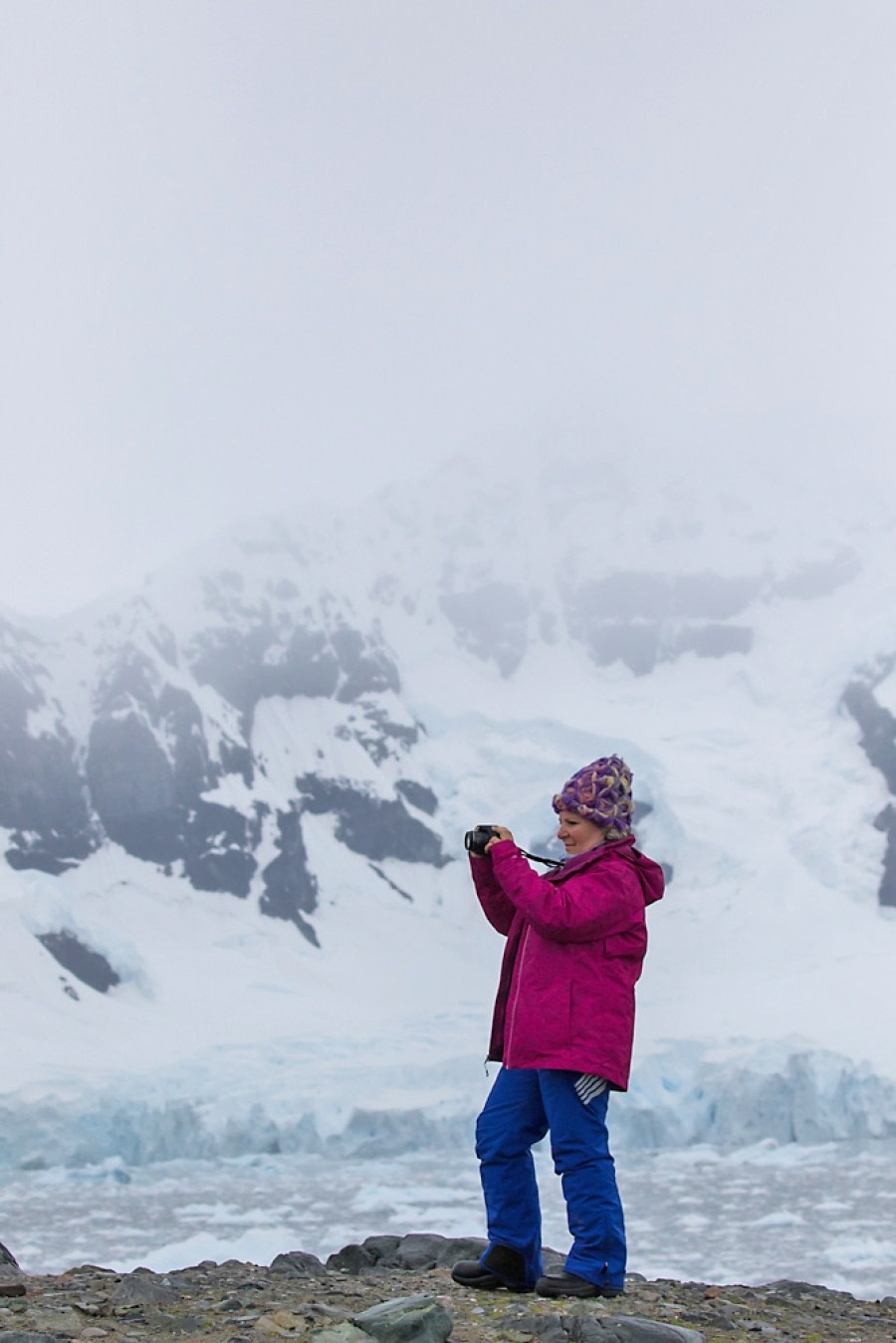
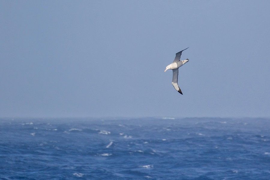
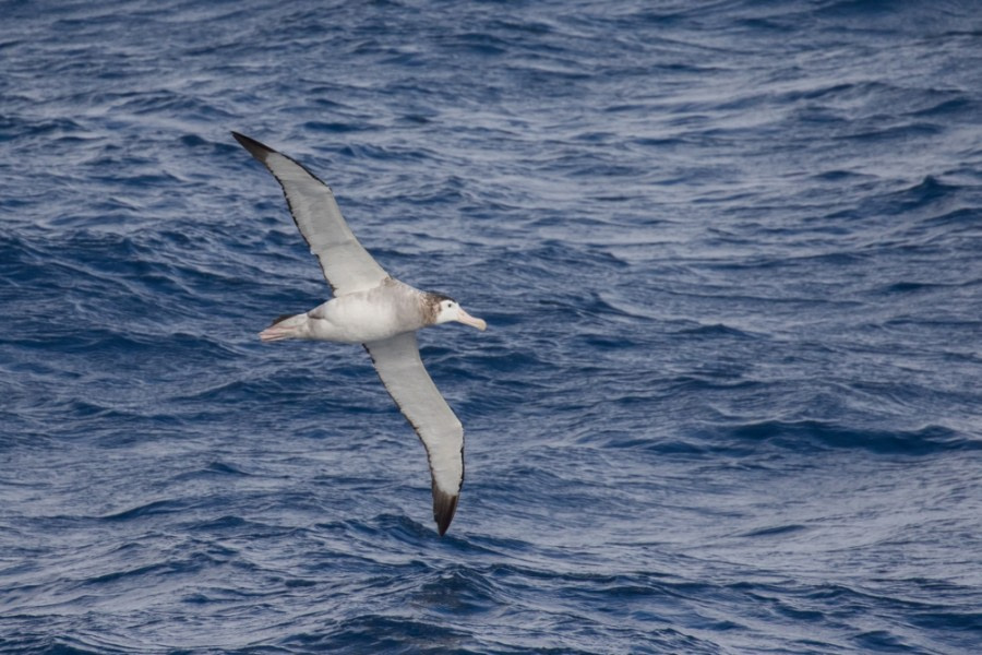
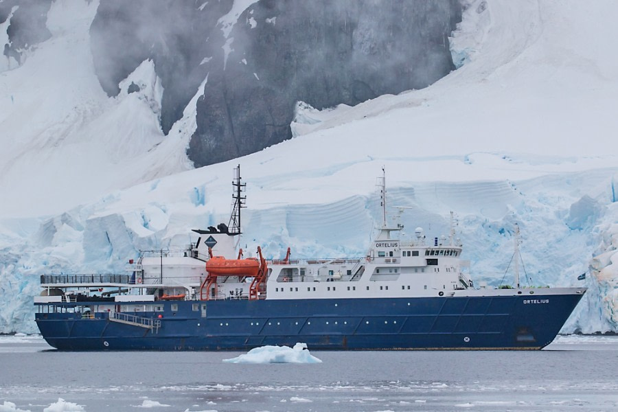
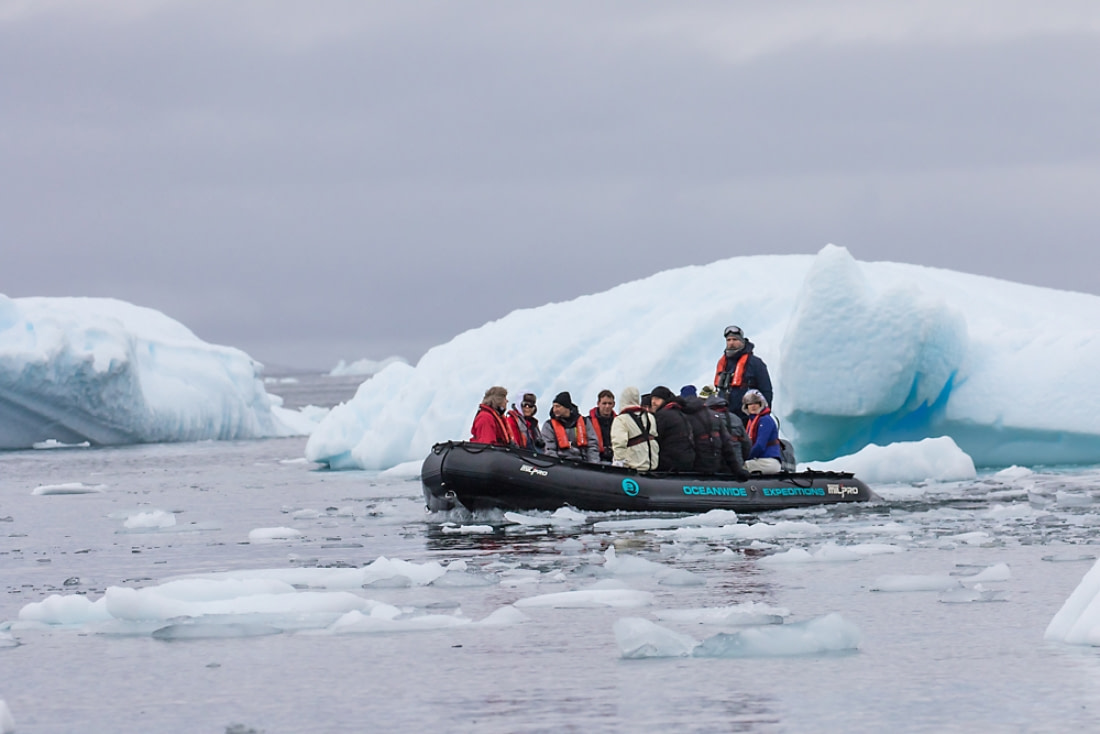
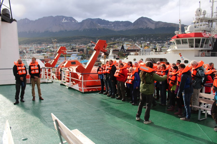
Boarding Ortelius started late in the afternoon and we were soon checked in by our Hotel Manager and his assistant (DJ and Sava). We were shown our cabins and had some free time to get unpacked and settled in. Lovely to know that we don’t have to change our ‘hotel’ again until we’re back in Ushuaia. We soon began exploring our new home; perhaps the most important place to find was the Bar on Deck 6, where coffee/tea can be accessed 24/7 and where our bartenders can often be found if we fancy something stronger. Of course doors to the outside deck-space were also important to locate, so that when ‘albatross’, ‘whales’ and other delights are announced, we know how to get out there as quickly and efficiently as possible. A bit later we were summoned by Expedition Leader Lynn to a mandatory briefing in the Lecture Room on Deck 3. She welcomed us on board and introduced Third Officer Warren, who gave an all-important Safety Briefing and Lifeboat Drill. Now we are aware of what we should do if we see a fire or man overboard, and know precisely what to grab and where to go in the event of the ship’s general alarm going off. Seven short and one long blast calls us (warmly dressed) to the Bar, which doubles as our muster station. Once we are all there, radio communication between the bridge officers and ship’s crew keeps us informed of developments. The ‘abandon ship’ signal is a verbal command given by the Captain or Chief Officer, and we hope that today is the only time we hear it, followed by the reassuring words “for practice only”…Filing outside in orderly fashion and gathering next to the lifeboats completed the drill; we were then free to continue our explorations of the ship, or come out on deck with our cameras to enjoy Ortelius’ departure from Ushuaia and progress down the Beagle Channel. Before dinner we again gathered in the Lounge/Bar on Deck 6 in order to meet key crew/staff and learn about ship routine during our voyage. Hotel Manager DJ imparted useful information about mealtimes, Internet/Webmail access and treating the toilets nicely. He was followed by Expedition Leader Lynn, who introduced Captain Ernesto – the person who will get us there and back again safely – and then handed over to her team of staff for self-introductions. We raised a glass of bubbly (or orange juice) to the success of our voyage and then it was time for our first dinner aboard. After dinner Dr. Veronique was available in the ship’s hospital to hand out seasick medication and valuable advice. A stroll on deck to watch Humpback whales flipper-waving and the local bird population on the wing, a cup of tea or something stronger, and then most of us fell into bed after a busy and exciting day, hoping for smooth seas to lull us to sleep. Tomorrow morning will find us well on the way to our first stop.

Day 2: At Sea towards the Antarctic Peninsula

At Sea towards the Antarctic Peninsula
Datum: 21.02.2018
Position: 56°38’S, 065°50’W
Wind: NE 7
Lufttemperatur: +11

We became aware of a bit of more movement about 3 am on board Ortelius as we emerged from the Beagle Channel and headed out into the Drake Passage. Still, most of us slept well, tired from our long journey to the bottom of South America. As we woke up the wind had changed direction and with strong northerly winds we felt the ship surfing the waves on its way south. Full speed towards Antarctica in other words! Breakfast was served from 8 – 9 am and it was well attended, considering we were all still developing our sea legs. After breakfast all the kayakers met with Louise and Zet for an important briefing prior to setting out for their first paddle - hopefully the day after tomorrow. Next up was a mandatory meeting for all divers – who got together with their diving guides in the Lecture Room to find out how their operation was going to work in Antarctica. The rest of us can’t wait to hear from them what’s going on under the waves while we focus on the wildlife and scenery on the ice and above the water. Then it was lunchtime. Most people made it athough seasickness was affecting some. The best solution is either to go out on deck and admire the seabirds, while keeping track of the horizon; or to go to bed and stay horizontal… A few of us took a siesta after lunch while we had the opportunity. After all, once we arrive at the White Continent we hope (weather permitting) to be very busy. This afternoon was a good time to visit the Bridge and get to know some of the officers and crew who work at the nerve-centre of the ship – it also has great views of birds without getting cold out on deck. The afternoon’s entertainment continued at 2.30 pm with Martin’s lecture on ‘Sea Birds: Masters of the Sea and Sky’ about seabirds’ incredible adaptions that allow them to spend their entire life over the ocean waves. Eventually we came to the last organised activity of our first day on Ortelius – Recap & Briefing at 6.30 pm. We like to meet just before dinner in order to summarise what we did and saw today and to allow our Expedition Leader Lynn a chance to preview tomorrow. This is also an opportunity for passengers to ask staff specialists questions in their field and for said staff to impart important information connected with where we have been or are going. By dinnertime we knew a lot more about Sir Francis Drake (of Drake Passage fame) from Eduardo and seabird identification by John. Dinner followed, with a choice of meat, fish or vegetarian dishes as the wind picked up considerable with gusts up to 65 knots outside. It was good to be inside and not on deck in these conditions. This might be interesting night. Our fingers are crossed that we don’t get too much rock n roll!

Day 3: At Sea towards the Antarctic Peninsula

At Sea towards the Antarctic Peninsula
Datum: 22.02.2018
Position: 60°42’S, 062°09’W
Wind: NNW 6
Lufttemperatur: +6

When we went to sleep last night, we were still heading South across the Drake Passage and we had gusts of wind up to 60 kts. The sea were very rough, reaching a sea state of 10 in the Beaufort scale. Consequently the ship rolled and rocked with the waves and it was not a surprise that there were some cases of seasickness. The wind decreased as the day broke but the sea was still in a confused state, with waves hitting us from all directions. However, this was not an excuse for not having lectures and our day went by introducing everyone to the safety issues related to the activities we are planning to undertake in Antarctica. Those of us interested in camping were briefed by Ben and his team about the conditions and the equipment that should be used to camp, as well as what the campers should expect regarding weather conditions and temperature. Later on in the morning Louise, our kayak leader, made a similar presentation about kayaking in Antarctica and the dangers and potential risks. In her lecture Louise gave recommendations about how to dress properly as well as how to handle the kayak adequately in cold waters. After lunch it was the Divers turn for their briefing. Henrik, onuur die team lead, briefed the divers about safety and dive procedures onboard Ortelius. The divers are expecting to undertake a series of dives in areas near the places were the rest of us will be onshore. Later in the afternoon all our guests had to attend the International Association of Antarctic Tour Operators (IAATO) mandatory briefing which deals with the codes of conduct that our guests must observe while being ashore. The IAATO defines the policies of all the tour vessels visiting Antarctica under the umbrella of the Antarctic Treaty. The treaty regulates the use of its land and the conducts that scientists and visitors should follow while visiting because Antarctica does not belong to any country nor to any other legal entity and is a territory devoted to "science and peace." By the end of the afternoon, we started to approach the south west part of the South Shetland Islands. The fog started to dissipate as we came closer, allowing us to view Smith Island and the highest point of the South Shetland Islands, Mount Foster, which rises 2100 meters above sea level. We crossed the Boyd Strait as we sailed next to the island. The whole scene was magnificent. Around the ship we had many Wandering Albatrosses, Cape Petrels and Wilson's Storm Petrels. We proceeded across the Bransfield Strait and started our approach to the Errera Channel as the night fell.

Day 4: Cuverville and Danko Islands

Cuverville and Danko Islands
Datum: 23.02.2018
Position: 64°40’S, 062°37’W
Wind: E 5
Lufttemperatur: +3

We awoke to calm seas under an overcast sky. The Drake and it’s swell borne maladies are a thing of memory as the voyage to Antarctica ends and our real journey begins. The Antarctic peninsula is a unique place on our planet, nothing like anywhere else on earth. It combines steep peaks; crenellated and looming, glaciers pouring forth from the loftier plateaus in chaotic confusion and penguins - lots of them! All three are amazing to witness, but the penguins were the main draw for today. First up was Cuverville Island. Cuverville Island rises like a dome shaped sentinel guarding the northern limits of the Errera Channel. Named after Jean Marie Armand de Cuverville of the French Navy, it is home to over 1 billion* (*number may be exaggerated…) Gentoo penguins. On approach, the distinctive eau d’guano was unmistakeable and was the first indication that penguin observation wasn’t going to be quite how Disney had depicted it. Landing at the cobbled beach, it was also immediately apparent that the ‘5m rule’ was going to be hard to abide by. Particularly with uncooperative Gentoo chicks! Far too inquisitive to act in accordance with any laws, these daring youths gave many a guest an experience they’ll never forget and photos to enchant the grandchildren with. Whether it was nibbling the end of walking poles, chasing one of the adult Gentoo's for yet more food or frolicking in the surf, these penguins were a delight to spend time around. All in all a textbook penguin encounter - the perfect balance between cute and stinky! A well deserved meal at lunchtime was followed by our afternoon excursion to Danco Island. Danco was the site of a small FID base, unused since 1959 and eventually deconstructed and removed in 2004. It was set up in order to survey and map the geology of the local area. Now all that remains is the concrete plinth on which it stood and a simple plaque to commemorate it’s purpose. It always makes me stop and think of how life must have been like for the three or four personnel stationed here. With meagre supplies and limited communications, a winter spent here in isolation awaiting resupply and news from the outside world must have been a harsh exercise in survival! For the many that undertook the short hike up the hill to the summit of Danco, the view did not disappoint. From this vantage point it becomes apparent that Danco Island sits in a cirque of mountains and glaciers culminating in extensive ice cliffs. Frequent creaks and groans could be heard reverberating around this natural amphitheatre serving to remind us that this is an extremely active area and in part explains the myriad of sculpted icebergs sitting in the bay. A truly awe-inspiring sight and a fine way to finish our first day in Antarctica! Camping night 1 – February 23rd After spending our first day in Antarctica, we went back to the ship to get ready for dinner and our first attempt for camping. Even if weather conditions were not great, Ben and Iggy took the campers to Kerr Point in Ronge Island. As soon the group arrived to the camping site, nasty clouds started covering the sky very fast but as Antarctica is very unpredictable and changeable the chances for the weather to improve or the rain to continue were 50 -50, so the happy campers started digging holes in the snow to set up the sleeping kits but finally the rain came and it was not light at all. It didn’t take too long for the guides to make the decision to send the people back on board the Ortellisu. It probably took no more than 10 minutes for the Captain to launch the zodiacs and Arjen and Andy picked them up in the middle of the rain. Even if the camping was not fully completed, everybody was very happy to have had the experience to be outside in the white continent but there were also glad to be back to the warmth and comfort of Ortelius for a few drinks at the bar.

Day 6: Orne Harbour and Neko Harbor

Orne Harbour and Neko Harbor
Datum: 24.02.2018
Position: 64°36’S, 062°34’W
Wind: SE 5
Lufttemperatur: +4

It was a cloudy morning, but there was little or no wind, so conditions were good for an excursion. We had a zodiac cruise for everyone at Orne Harbour. The waves picked up a bit as we got started loading the Zodiacs, but the enthusiasm of the passengers did not cool down. It was our opportunity to see Chinstrap Penguins, hearty little birds that prefer to live on rocky cliff sides and scree slopes - places inaccessible for us to land. After cruising past the Chinstrap colony, we drove deeper into Orne Harbour and checked out the icebergs and the beautiful views of glaciers surrounding the area. We landed at Neko Harbour a bit later in the afternoon after lunch. Neko is a small indentation in Andvord Bay named after an old whaling vessel which used the little harbour for one season. Once we were ashore we all began with observing the Gentoo Penguins nesting down lower on the hillside. Quite a few of us followed Arjen, who offered a short hike to a view point close to a rocky point that was full of Gentoo chicks. From that observation point there was an amazing view of the surrounding landscape– at least for most of the time when the fog stayed away. Since the Ortellius couldn’t approach very close to the landing site, the drive back and forth in the zodiacs was very enjoyable as we ventrured between ice brash and big icebergs. People enjoyed viewing this amazing ice- and seascape, as well as the Gentoo Penguins. Although some passengers were cold (specially the divers), they all thought it was worth the effort to push themselves a little and take in the amazing Antarctic scenery.

Day 7: Paradise Harbour – Brown Station & Stony Point

Paradise Harbour – Brown Station & Stony Point
Datum: 25.02.2018
Position: 64°53’S, 062°52’W
Wind: calm
Lufttemperatur: +5

We woke up to a moody Antarctica in shades of grey, blue and white. Light rain mixed with snow was gently falling over the calm water mirror and brash ice surrounding the ship. After breakfast, we went for the first excursion for the day; the Argentine-managed research base named Brown Station in the aptly named Paradise Harbour. Zodiac cruises offered some close-up views of crabeater seals in the water and Antarctic cormorants on the cliffs. Those of us who climbed the snow hill behind the research station had an astonishing view over Skontorp Cove and the enormous glacier behind. The stars of this place, the Gentoo Penguins, were also present and we were able to see all the daily concerns of a penguin colony as the penguin parents coming and going from the ocean in continuous shuttles up and down the slopes to feed and care for their chicks. We did a brief transit to the nearby Stony Point after lunch. Conditions remained good with little to no wind and good visibility. The rain, however, did not want to stop. A few Gentoo Penguins welcomed us on the small island as we stepped a shore, while a Weddell seal was slumbering in the snow above the beach. After a zig-zag climb in the deep snow up to the top off the hill we were enamored by our second astonishing view of Paradise Harbour with the Gerlache Strain to the west and blue glaciers in the east. Antarctic Terns and Kelp Gulls were flying above our heads during our afternoon of calm winds and smooth seas below us. Back on the ship at around 5 pm, some of us were lucky to see crabeater seals close the ship while others relaxed in the bar. Excitement was running high at Recap that evening; not only were we eager to hear about tomorrow’s Peninsula activities, but over 30 aspiring Campers were hoping to spend the night out on the ice. Unfortunately the rain refused to stop and even got worse during the evening and camping was cancelled - not only because it’s not very pleasant to camp in the rain, but mostly because of the risk of even worse weather during the night.

Day 8: Pleneau Island and Peterman Island

Pleneau Island and Peterman Island
Datum: 26.02.2018
Position: 65°00’S, 063°49’W
Wind: W 2
Lufttemperatur: +5

This morning, we were woken a little bit early from our restful sleep after yesterday’s excitement. We were leaving the Southern Gerlache Strait and heading towards the Penola Strait. The route in between took us through the thousand-metre deep, hundred-and-sixty-metre wide, highly picturesque Lemaire Channel. It’s only nine km long, but this was one leg of our journey that was well worth getting up early for. The passage is notorious for having large icebergs inside so we tentatively pushed ahead, weaving in between the ice and finding a path just wide enough for our ship to glide through. At the end of our transit of the Lemaire we entered into a large bay which is the northern end of the Penola Strait. The ship arrived at the shores of Pleneau Island where we were met by spectacular weather. The ship’s crew lowered the zodiacs from the ship once again and we all piled in for what promised to be great Zodiac cruising among the icebergs. This bay was a mass of towering icebergs, each a sculpture shaped by the wind and waves and eventually blown into this protected harbour by storms and then trapped in the shallows. Massive arches fractured by time seemed ready to crumble and fall down at any minute. The now familiar Crabeater Seals and a surprising number of Leopard Seals were lounging on icebergs, digesting their latest belly full of krill. A long but scenic drive back to the ship brought us back to the warm and dry Ortelius! Lunch was very welcome. After lunch we moved around the corner and farther down the Penola Strait to Petermann Island, the farthest southern point of our journey. The wonderful weather continued as we went ashore to conquer one more island. The main aim of visiting this spot is to view the Adelie Penguin, one of the true ‘Antarctic’ penguins. Gentoo Penguins and Antarctic Shags also call Petermann Island home. The Adelie colony here is being studied and so we couldn’t approach too close and we really didn’t need to since most of the Adelies had already completed their breeding cycle and there did not appear to be any chicks remaining at the colonies. We did however, manage to find a few Adelies that were either beginning or in the middle of molting all there feathers and growing in new ones. After viewing the Adelies (and the everpresent Gentoos of course) the staff marked a walk up the hill and around the corner. That route gave us a much-appreciated leg stretch and fantastic views of a small ice-choked bay on the other side of the island. From the end of the island we gazed south, towards the Pole…a mere 1500 miles away! Recap & Briefing was all about tomorrow’s activities and it contained some more information about Petermann Island. Eduardo then told us the names of a number of the mountain peaks we could see from the island as well as their elevation, mostly named by Gerlache and his French friends. We also finally had a chance for a few passengers to go camping overnight. It was great fun and 28 souls made it out for an overnight experience on shore in Hovgaard Island. Arjen and Andy shuttled them from the ship to the island where Ben and Iggy where waiting. Port Lockroy is our goal for tomorrow, weather permitting, we will disembark on this British station for some post carding from Antarctica! Dreaming on this plan, and a very full day behind us, we are going to our comfy beds on board… Salud! Camping Night 4 – February 26th Unfortunately due to the inclement weather, night 2 and 3 had to be cancel but with much better sky on the 4th and night campers were ready to go. As Iggy and Ben wanted to give the same opportunity to everybody who could not go the previoius days that were cancled, they organized a lottery to fill up the empty spots for that night. Paper by paper the names came up and we were surprised about how many people that were given the opportunity decided not to go until one of the passengers showed her huge heart and kindness by saying she already had the experience to be on the first night that got canceled after 30 minutes on shore and she wanted to give her place to somebody else. =) With a full group of campers and the night getting close, again Arjen and Andy dropped the people off at Haalvguard Island. Our very productive group was full of energy and set up the sleeping kits while playing and making jokes the whole time, but as soon as it got dark most of the group went to sleep except for a couple who decided to stay longer taking cool pictures on the coast. Around 1 AM rain arrived and it did not stopped for around two hours. The rain was followed by a heavy dense fog that stayed until the wake-up call to pack and get back to the ship. In less than 30 minutes the whole group was ready but visibility was not good due to the dark and fog. The Ortelius was just at 600 meters away and could be heard but not seen. Fortunately after 15 minutes it got much better so John and Martin took the people back safe and happy.

Day 9: Port Lockroy on Goudier Island and Jougla Point

Port Lockroy on Goudier Island and Jougla Point
Datum: 27.02.2018
Position: 64°35’S, 063°39’W
Wind: NE 2
Lufttemperatur: +3

Early in the morning Martin and John ventured out into the fog and dark to retrieve our slightly soggy campers from Hovgaard Island. Once everyone was safely back onboard the Ortellius we journeying once more northwards back through the Lemaire Channel. Afterwards we crossed over the Gerlache Strait to reach the southern edges of the Neumayer Channel. Numbers permitted ashore dictated events for the mornings activity - a split landing in the bay of Port Lockroy between Jougla Point and Goudier Island. Jougla Point is an ice free promontory of Wiencke Island and is home to breeding Blue-eyed Shags and the ubiquitous Gentoo Penguin. Many yachts use the relatively sheltered waters of Port Lockroy as a natural harbour and anchorage whilst travelling down the peninsula and this is also the reason for an abundance of whale bones on the shores. During the whaling years, the bay was used by factory ships partly due to the aforementioned shelter afforded but also because the glacier and it’s meltwater provided the reliable supply of fresh water required to keep the boilers functioning. Separated by 50m of water from Jougla Point lies Goudier Island named by Charcot during his expeditions down the peninsula in the early 1900’s. A hut was erected here in 1944 by the British as part of Operation Tabarin. This was a reconnaissance operation aimed at detecting German naval movements in and around Antarctica. It was feared that the vital supply route round Cape Horn could be severed by German U-boats and accordingly a series of strategic listening posts was established along the peninsula in or around natural harbours. These huts never saw hostile action, but following the war many continued to be used for survey and research work as part of the Falkland Islands Dependencies Survey (FIDS) and subsequently the British Antarctic Survey (BAS), the UK’s governmental operations in the Antarctic. The hut in Port Lockroy is the only one currently occupied (and only during the austral summer) by a compliment of four who run the museum and shop. A short transit during lunch repositioned Ortlelius off Dorian Bay and the huts at Damoy Point. These huts belong to a later, more recent period in Antarctic exploration. The British Antarctic Survey hut at Damoy was occupied for only twenty years between 1973 and 1993 and was used almost solely for logistical reasons. Ski equipped planes would land on a snow runway or skiway on the glacier behind before refuelling and proceeding to bases further south at Rothera Research Station and Stonnington Base. The construction of a new gravel runway at Rothera allowed wheeled planes with greater range such as the De Havilland Dash 7 to fly continuously south from the Falkland Islands and signalled the end of Damoy as a logistical station. It is maintained now as part of the UK Antarctic Heritage Trust but remains unoccupied unlike Port Lockroy. Dorian Bay was also the spot many chose to take in the soothing spa waters of the Antarctic by undertaking the polar plunge. A chilly wind and overcast sky wasn’t enough to put off you intrepid adventurers and numbers were higher than I imagined - fair play to all those who took part! I of course would have loved to have joined you but I had a boat to drive… Ah well, maybe next time…

Day 10: Foyn Harbour and Enterprise Island

Foyn Harbour and Enterprise Island
Datum: 28.02.2018
Position: 64°32’S, 061°57 W
Wind: N 2
Lufttemperatur: +4

Strong headwinds were forecast for our return across the Drake passage which unfortunately resulted in a shorter than planned programme for our final day on the Antarctic Peninsula. Nevertheless, we managed to take full advantage of the time allotted as well as some pleasant weather - a phenomenon this cruise had in short supply! A fleet of six zodiacs was lowered from deck five and filled with passengers excited for their last trip off the ship. And what a last cruise! Initially, we headed straight out into open water for a closer look at two groups of Humpbacks. There was a mother and calf resting on the surface whilst another pair were acting more playfully towards the east. It’s amazing to see these leviathans of the deep from water level as opposed to the decks of Ortelius. It gives one a real appreciation of their immense size and scale and seeing them like this in the Antarctic landscape is a privilege few get to experience. A wonderful bonus to our coastline cruise! Foyn Harbour is another naturally sheltered bay and lies on the northern coast of Nansen Island. As we cruised closer in to land, we encountered fur seals playing on the shores and nesting shags on some outcrops. There were also two rather dilapidated looking wooden boats, another relic from the whaling years. These were water boats, used to transfer large chunks of ice hewn from the surrounding glaciers to feed the ships boilers. During the early 1900’s, whaling tactics changed towards the use of factory ships; larger vessels designed solely for the processing of whale carcasses rather than their procurement. These ships were much more efficient and barely any of the carcass was spared. The bones were even drained of any last residue of oil using vast boilers and it was these boilers that demanded the ice carried by those wrecked water boats we saw on the coast. Moving along, we arrived at today’s main attraction. The wreck of the Guvernøren, one of those mighty whaling factory ships. It’s bow stands proud of the water and, under grey skies, takes on a more sinister air as the twin anchor holes peer down menacingly upon the zodiac. It conjures an image of Ted Hughes’ ‘Iron Man’ and acts as a memorial to man’s insatiability and greed from this dark period in Antarctic history. It was one of the most modern factory ships of it’s time but fire broke out onboard in 1915. It was then purposefully ran aground and scuttled by harpoons in order to salvage as much as possible from her. No hands were lost but the wreck still contains barrels of whale oil unable to recovered and bones can still be seen inside the ships boilers. And so ends our sojourn to the Antarctic Peninsula and we begin the journey north once more. Sailing up and out of the Gerlache Strait and into the Bransfield with Brabant Island to our west and the mighty Danco Coast to the east. The clouds have lifted, icy mountains reveal themselves and the sun shines as Humpbacks breach on the port side. Makes you want to come back, doesn’t it?

Day 10: At Sea towards Ushuaia

At Sea towards Ushuaia
Datum: 01.03.2018
Position: 61°01’S, 063°02’W
Wind: NNW 5
Lufttemperatur: +4

To disappointment of some we were not woken by Lynns voice today. Others just cherished the extra 15 minutes of sleep until DJ called us to breakfast. The Drake wasn’t extremely rough, by Drake standards that is. Several of us were clearly using a different scale and the doctor was quite busy handing out pills and patches. Most of the morning it was kind of foggy outside so not a lot was to be seen outside. Inside the ship, our lecture program started. To relief of many it was decided to move the lectures from the lecture room to the bar, making it possible for people who were just a little seasick to attent as well. We started off with Martin telling us all about the different kinds of penguins we had seen and their biology. A little later Louise took over with her talk a about the early whaling history of the places we had visited. It turned out there was even a family connection to the story. After lunch, Arjen gave a presentation about the effects of climate change in both Polar regions. This ended with the hopes we were making a change in the right direction and a short discussion about what we could do to reduce our own carbon footprint. Later Eduardo finished todays lecture program with an overview of current science in Antarctica. Meanwhile it had cleared a little outside and some birds could be seen. Several Soft-plumaged and White-chinned Petrels were seen and also some Black-browed Albatrosses. At recap Lynn showed us some weather charts and a movie of what the Drake can look like as well. Arjen told us how to identify whales, Iain took us on a trip to the top of Mount Vinson, where he had worked and then Louise told us about Krill and the whales that feed on them. After DJ had explained us the procedures for the last day, Arjen finished off with a short movie of our passage through the Lemaire Channel. It was beautiful to look back at this spectacular crossing. After dinner, where many plates were taken to cabins, many of us that were able to make it to the dining area retired to our cabins and tried to get some sleep while gently being rocked around by the ship. Others went for a drink in the bar and enjoy the second-to-last evening of the trip a little longer.

Day 11: At Sea towards Ushuaia

At Sea towards Ushuaia
Datum: 02.03.2018
Position: 57°28‘S, 064°53‘W
Wind: WNW 8
Lufttemperatur: +8

We had a rocky night and it was a bit difficult to sleep due to the constant and and occasionally sudden movements of the ship. The Drake Passage had little mercy on us this time, and our ship did not stop pitching and rolling through the whole day and the movement only diminished as we came closer to the continental shelf. Our plan is to conclude our trip by moving over the continental shelf by the end of this day and sailing through the Beagle Channel. Once we enter the Beagle Channel, we will request our Argentinian Pilot to come onboard and he will be the one who sailes the ship and conducts the maneuvers necessary to sail through the channel and to dock the ship at the pier. During the crossing of the Drake, we had foul weather, mist and high weaves. The Drake is well known for this foul weather because it is the place where different ocean currents meet. Basically, cold water mixes with warmer water at this place and this can produce quite rough conditions. By mid morning Sun came through the clouds and warmed up the ship a little bit. We enjoyed the company of a couple of Wandering Albatrosses flying around the ship. We also saw a couple of White-chinned Petrels flying around. Late in the morning Eduardo gave a lecture about the first circumnavigation of the world by describing the trip organized by Ferdinand Magellan. Magellan embarked in his trip with 5 ships - the Concepcion, Victoria, San Antonio, Santiago and Trinidad along with 270 crew. Only 1 ship and 18 men returned to Spain 3 years after their departure. In his lecture Eduardo described the perils, sufferings and dangers of the trip. He mentioned how we learned about this trip, thanks to Antonio Pigafetta, the scribe of the trip who wrote "First Voyage Around the Globe". At the end of his talk he also mentioned the second circumnavigation made by the Spanish as well as the third circumnavigation, made by Sir Francis Drake about 55 years later. After lunch, we had the chance to hear the stories of Antarctica told by two of our staff members, John Carlson and Iain Rudkin who have worked at a variety of locations in Antarctica. John told us of his experiences working at Palmer Station, a U.S. Antarctic station in the Antarctic Peninsula. Through this lecture he revived his memories about his job at the base and more importantly, he shared many personal details about his time working on the Antarctic Peninsula. His stories were complemented by the stories Iain who has been climbing and giving support to scientist throughout many remote areas in the white continent. This activity was nice way to conclude our staff activities onboard and to reflect upon the visit to Antarctica that we went through during the last days. As we sail our last miles, we plough through the waves into a blue sky, heading to Ushuaia, the port where our ways part and the port where our re-encounter civilization will happen. We sail onboard our ship, the M/V Ortelius, filled with elation and the emotion of having payed a visit to the most pristine, isolated and remote continent in the world. "We shall not cease from exploration, and the end of all our exploring will be to arrive where we started and know the place for the first time" T.S. Elliot

Day 12: Ushuaia, Argentina

Ushuaia, Argentina
Datum: 03.03.2018
Position: 54°49‘S, 068°17‘W

All good things come to an end, as they say. Today was our last morning on the Ortelius. After a last night in our cabin, which had come to feel like home, it was time to move on to new adventures. We put our luggage in the corridors this morning as asked, so the crew could take it off the ship for us. After one last wakeup call from Lynn and one last breakfast on board, it was time to say goodbye. Goodbye to our ship and its crew and staff, and to our new friends. Arrangements were made to stay in touch and farewells were said. We could look back on an excellent and successful trip, and all of us had many memories of wildlife and spectacular scenery during our days at sea, Zodiac-cruising activities and shore landings. At 8:30 am we handed in the keys to our cabins, picked up our luggage from the pier and made our way into Ushuaia or to the airport for our onward journeys. May we meet again somewhere, some day! Thank you all for such a wonderful voyage, for your company, good humour and enthusiasm. We hope to see you again in the future, wherever that might be! Total Distance Sailed: over 1650 Nautical Miles On behalf of Oceanwide Expeditions, Captain Ernesto Barria, Expedition Leader Lynn Woodworth, Hotel Manager Dejan Nikolic, and all the crew and staff, it has been a pleasure travelling with you.

Loading