Oceanwide guests make fourth charting of an Antarctic bay
It’s not every day we are able to report that our guests were involved in a noteworthy event of polar exploration, but today is one of those days.
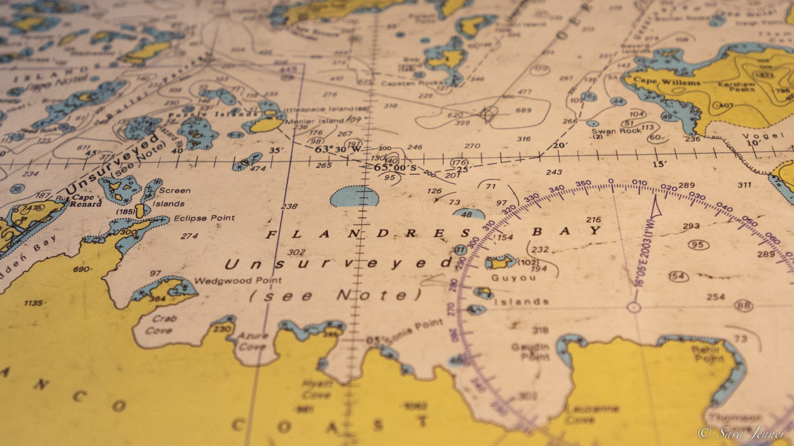
On the evening of December 11, 2022, our guides and guests mapped an area around the largest of the Guyou Islands in Antarctica’s Flanders Bay. Until then, this spot in the northwestern Antarctic Peninsula had only been charted three times since 1898, when it was roughly mapped by the Belgian Antarctic Expedition.
This activity, which involved our expedition leader, second mate, and other members of our onboard staff, was accomplished using the OLEX depth mapping system.

Developed by Olex AS in the Norwegian city of Trondheim, Olex employs sonar and GPS technology to collect and continuously update sea depth data, producing 3D visualizations of the seabed in real time. Our guests were able to contribute their findings in Flanders Bay to the growing Olex database, which is used by seafarers in fishing, port work, aquaculture, and subsea piping, and more.
As Flandres Bay has not been fully surveyed and few vessels have ventured into it since it was first mapped, no formal directions are given for passages in and around the bay. This makes the area relatively unknown in terms of our usual polar destinations, which only added to the excitement and sense of accomplishment our guides and guests felt during their charting excursion.
The outing took place between 16:00 and 20:30, with two expedition staff and one bridge officer manning the Zodiac that carried the Olex. After roughly a half hour spent setting up the system, adjusting settings, and establishing a connection to the bridge of Ortelius, we invited our guests to board our other Zodiacs and join in the charting process.
Bridge staff were able to watch the progress as it occurred. Meanwhile, our staff explained to guests how the Olex works and answered questions about the charting.

At the time of our excursion, Flandres Bay was covered in sea ice that made it impossible to go very far into the bay. We opted then, to embark on a Zodiac cruise near the ship while the Zodiac carrying the Olex moved closer to the Guyou Islands.
The Guyou Islands lie in the center of Flandres Bay, and it was our goal to find out if ships like Ortelius could conduct landings there. In the process of exploring this option, our guests enjoyed seeing many huge and beautiful icebergs, crabeater seals, and krill.
Once we got closer to the largest of the Guyou Islands, we spotted a small headland clear of ice and moved toward it. We were lucky that the water was low, enabling our staff to land with the Zodiac in what may have been the first landing on this island in over a century.

Unfortunately, however, the headland was too small to safely allow for guests to land.
Instead, we circled the island to see if there were other options. While we did not find any landing sites, the depths around the island allowed us to approach with the vessel so our guests could get splendid views of this seldom-visited corner of Antarctica.
The charting activity was a great success, an excursion that proved as fascinating to our guests as to our staff. We hope to return later in the 2022-23 season to continue our mapping efforts there. With the progress we have already made, our vessels can now approach closer to the large Guyou Island than before and, conditions permitting, explore farther into Flandres Bay.
Below is a list of what we believe to be the only charting events of Flanders Bay:
- Belgian Antarctic Expedition (1898)
- French Antarctic Expedition (1904)
- French Antarctic Expedition (1908-1911)
- Oceanwide Expeditions (December 11, 2022)
